
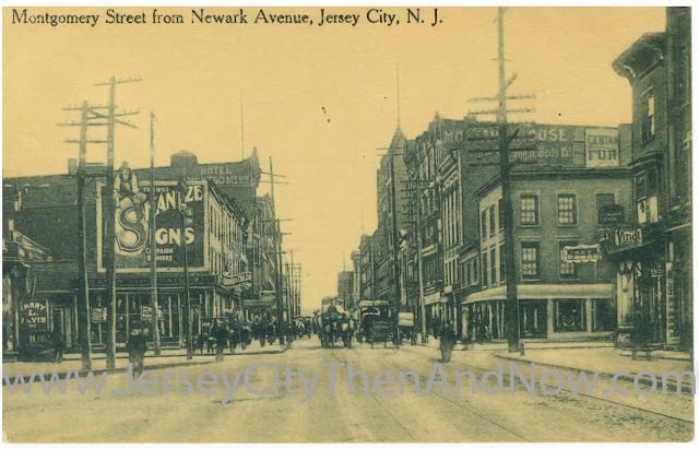
The photos in this post are taken from Montgomery Street looking east, towards the Hudson.
At the time when the old photo was taken, Montgomery intersected not only with Warren St but also with Newark Avenue. The ‘askew’ intersection of Newark and Montgomery can just barely been seen in the outline of the side walk at the left side of the postcard.
As mentioned in previous posts, a several block large area was razed in the 1950s to make way for what eventually became the Metropolis Towers. Newark was at the same time shortened to end at Railroad Avenue (now Columbus). It is likely that the widening of this part of Montgomery Street (that can be seen in images above) happened at the same time.
When looking at old maps, e.g. this from 1804, one can see how Newark Avenue previously had continued not only to Montgomery as in this postcard, but to York St. And even earlier, before Jersey City had become a town and it was ‘just’ a fort in what is now the Paulus Hook neighborhood, what became Newark Avenue was the one and only track that lead down from the palisades / heights, cutting through marshlands on both sides, to the fortification in Paulus Hook (Powles Hook) insert link to LOC.
Of the buildings in the old postcard, it’s only the buildings on the right hand of the street, beyond the intersection with Warren that are still standing today. One of them, Montak House (the name is painted on the side of the building in the old postcard, above an offer of single beds at 15 cents per night), has recently undergone extensive renovations to restore the façade. Kudos to the developers and/or historic preservation commission for safeguarding the façade of the building.
In a future post, I’ll upload a photo from the 1950s that shows Newark Avenue from Railroad Ave / Columbus Way leading to Montgomery Street, in which one can see these buildings (e.g. Montak House) in the distance. Stay tuned…
Always appreciate feedback and interaction – please use the comments functionality below and drop me a line if you have photos to share. And make sure to like the blog on Facebook / Google+ so that others that may be interested find out about this page!
Credits
The old postcard is from my personal collection.View Larger Map
Very cool to this Jersey City's history. I moved here last August to 50 Columbus, and really am intreated about the development around the area and what used to be here. Do you have any photos of this block where 50 Columbus is, Warren,Columbus to Marin Blvd, and the area east of here where that horrible white office tower is? Maybe something of 350 Warren? Are they going to demo that too?
ReplyDeleteThe red brick building to the right of the new image (where that sushi place today) is still there and for sale :)
ReplyDeletehttp://www.zillow.com/homes/for_sale/Jersey-City-NJ-07302/2105877523_zpid/60639_rid/40.718516,-74.035076,40.714877,-74.041744_rect/17_zm/?view=map