It's been years since I posted - life has got in the way. During this time I have collected historic images of Jersey City and scowered online photo collections in search for the same. This post shares some findings from the online searches.
Brooklyn Museum has many photos taken by a George Bradford Brainerd in their online collections: https://www.brooklynmuseum.org/opencollection/collections.
The photographer seems to have travelled around New York City metropolitan area and documented the landscapes and streetscapes he encountered. Mr Brainerd came to Jersey City and took these photos in 1873 (according to the information in Brooklyn Museum's database). The photos are of high quality (sharp and reveal details, e.g. far away details, business sign lettering, etc) and show overviews of the street scape, which makes it easy to see the macro changes (as opposed to just depicting one building at the time).
There are about 10 photos from Jersey City in Brooklyn Museum's collection. These are some of the very most interesting historic photos of Jersey City that I know of.
When creating this post I have not had the time to create the usual 'then and now' posts with the slider or provide extensive research. Instead I have used google street view to provide the approximate view of what the vista from the historic photo looks like today.
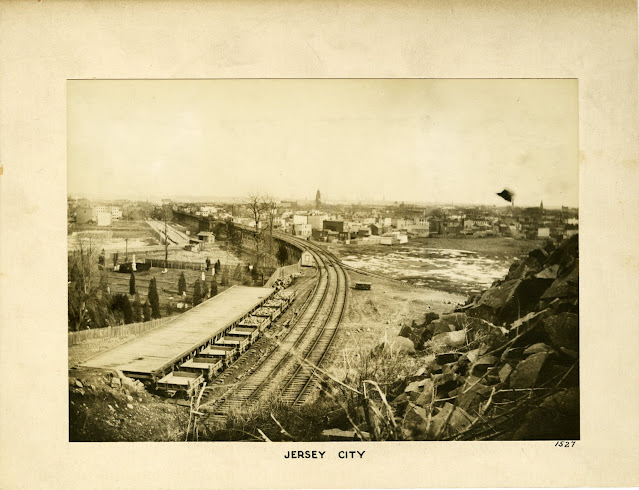
6th Street Railroad Trestle / Embankment in Jersey City
The photo below was taken from the heights looking down onto the elevated railroad trestle that ran from the heights and over the backyards between the houses on sixth and fifth street in downtown Jersey City. The trestle was the precursor to todays embankment.
Source: https://www.brooklynmuseum.org/opencollection/objects/192558
I added annotations to the photo below to help with orientation.
1873 Hopkins Map
This map from 1873 shows how the trestle ran through the backyards between 5th and 6th street. The map indicates that the trestle and railroad was owned by NJRR&T Co. I believe this is an abbreviation for NJ Rail Road and Transportation Company.
Now in Google Maps 3D
A triangle of low vegetation can be seen in the lower right of the 3D Google map. The surrounding ground is covered with trees. This triangle looks very much like the foreground in the old photo and may well be the exact spot from which the old photo was taken.
Next : Exchange Place, Jersey City in 1873
Of the 10 or so historic photos of Jersey City in Brooklyn Museum's collection, this is my favorite.
Source: https://www.brooklynmuseum.org/opencollection/objects/192560
The photo shows Exchange Place in downtown Jersey City. The photographer is looking west along Montgomery Street and has the Hudson River behind him.
The building in the middle of the photo, the one with the clock on the corner was located on the southwest corner of Montgomery and Hudson St. It seems to be the old Darcy building. The Darcy building is shown in an old drawing of Exchange Place from approximately 1840.
I have not been able to directly link to an image showing the 1840 drawing of the Darcy house, but it is available on page 41 in this book: https://www.google.com/books/edition/Jersey_City/GUWQLmEIGUwC
Google Street View Now
Today, the same location looks like this. What a difference 150 years makes...
What have you found?
What are your favorite online collections with historic photos of Jersey City? Use the comments functionality below to share!


