Tuesday, May 28, 2013

York Street / Henderson Street (Marin Blvd)

before
after


This street has changed quite a bit... actually this whole area of downtown Jersey City has been dramatically altered.

The area between
  • Henderson St (now called Marin Blvd) to the west and 
  • Greene St to the east, and 
  • Railroad Ave (now called Columbus Ave) to the north and 
  • York St to the south 
was razed in the 1950s to give way to high rise buildings. One project took a particularly heavy toll - the Metropolitan Towers.
From the late 1800s to the 1950s, this section of Jersey City was dominated by three to five story commercial brick buildings - the kind that are still standing on Newark Ave, between Grove and Jersey Ave. Many of the buildings were very ornate, as I will show in future posts.

But during the 40s and 50s downtown Jersey City had declined. It was because Jersey City was a railway hub, and the importance of railway had been giving way to cars and trucks. The housing stock reflected this downward slide with many boarded up and vacant buildings.

But what happened when planning for the high rise project that eventually became Metropolitan Towers seems excessive even against this backdrop - several blocks of downtown Jersey City was razed and two large sections of two streets were eliminated from the map.

Today Newark Avenue ends at Marin Boulevard, but it used to continue to meet Montgomery Street. There was also a street parallel to Newark Ave called Gregory Street. All of the buildings on all of the blocks facing these streets were demolished and the streets themselves literally vanished from the maps (and the real world).

The map below shows the streets and blocks before the demolition frenzy in the 1950s.


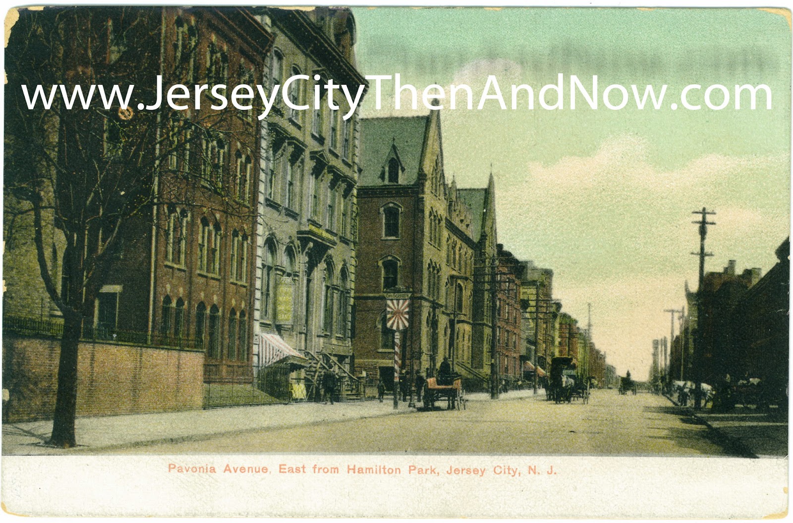
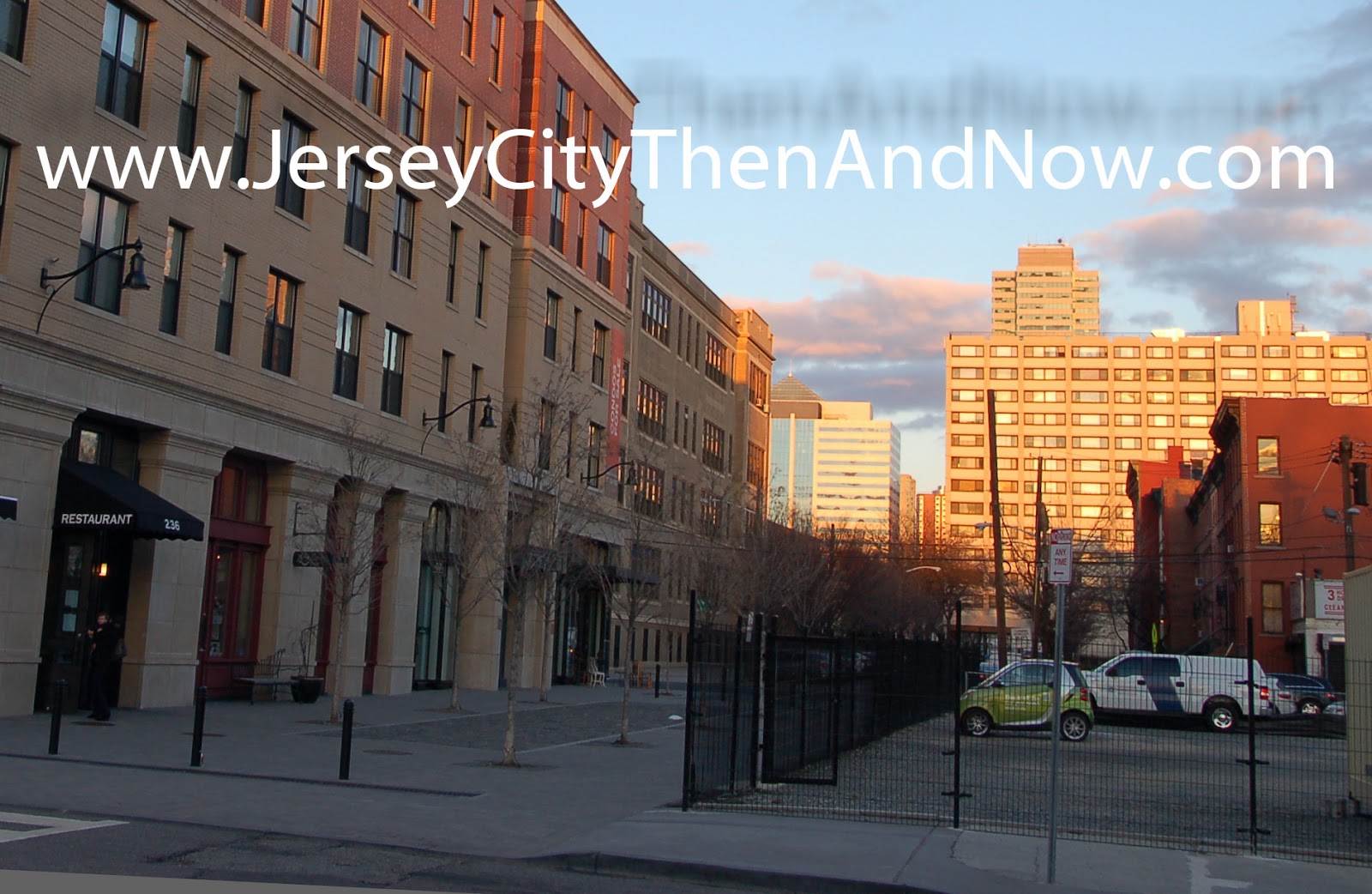
Going back to the photos : the photo is taken on York St looking west towards Marin Blvd (aka Henderson St.). The building on the right in the old picture was one of the buildings that was erased to make way for Metropolitan Towers  - it was the American Railway Express Co. stables.

Beyond the intersection with Henderson is the building that put me on the right track to locate where the old photo was taken - the corner building that currently houses a bodega. It was the bricked up windows on the second and third floor that provided the crucial clues - there are not many of those bricked up windows in downtown Jersey City.

I believe there are some aerial shots of the section of downtown available online from during the demolition work that made way for Metropolitan Towers - if you know where to find such photos, or have anything else to share, please post a link in the comments.


View Larger Map


Photo Credits
The map is from Rutgers, and the photos are from my collection.

Sunday, May 19, 2013

Hamilton Park / Pavonia Avenue

before
after


It took me a long time to understand exactly where this postcard photo was taken, despite the details of the location on the postcard. Today the location looks nothing like it did a hundred years ago - none of the buildings that are clearly visible to the left in the old post card are standing today. But the recent photo is taken in exactly the same location.

The first building on the left in the old postcard, behind the brick wall, is the chapel at St Francis Hospital. That whole structure can be seen in this older post. It was the postcard in the older post (that I got more recently) that confirmed the exact location of this picture.

The next building, the building on the corner of Erie St (202 Pavonia Ave at Erie St) with the sign outside was a bank - Fifth Ward Savings Bank.

The sign on the sidewalk looks very much like an advertising sign for Dortmunder Beer that I have seen in some other old post cards from Jersey City. But I am not sure if that is what this sign is advertising - the text is just too small to read.

The large building on the next block facing pavonia was St Micheals Home. I plan to feature that in a future posting

Note that Pavonia Avenue used to be wider than it is today. But I also believe that recently, before the construction of the current buildings, Pavonia Avenue was blocked by a hospital building at Erie, and did not reach the park.

I would like to hear from you! To post comments, you may have to click a 'No Comments' hyperlink below(not 100% intuitive, I know).


View Larger Map

Monday, May 13, 2013

City Hall / 2013 Jersey City Elections


Jersey City's mayoral and city council elections are on Tuesday May 14th. This is the most important local election in a long time and it will determine the future direction of our city and community.

So, if you have not done so already, take a few moments now and go to google/bing, search for Jersey City Mayoral Election or go to a local news papers (e.g. nj.com) and do some research on the candidates : what they stand for, what they have been up to in the past 4 years and what they hope to achieve for the city in the next 4.

And then do your civic duty & privilege and cast a vote for your candidate on Tuesday.

Have your say in the future of our city!

Friday, May 3, 2013

Hamilton Park - St Francis Hospital / Hamilton Square

before
after


A lot has changed at Hamilton Park during the last one hundred years, including in the last few years.
At the turn of the last century a beautiful hospital building that housed St. Francis hospital was standing at the Park.

I don’t know exactly when, but I believe it was demolished some time in the sixties or seventies based on old photos. It was replaces by a bunker-like structure. There are some interesting pictures here of what the bunker-like buildings used to look like right before they were demolished in 2006 / 2007 to give way to the latest developments.

In my opinion the current buildings are a vast improvement over what used to be there, and that they are residential, with the increased population density, means that the park is more lively too and more facilities (e.g. stores, restaurants) can be sustained in the local area - such as Mdm Claude's Wine Shop.

In the historic photo Pavonia avenue extends for at least several blocks towards the water. Now the street is blocked by a tall building and beyond that the Newport Mall blocks the path to the water. The second building on the left beyond the chapel was a bank building and on the next block St Michaels’s orphanage used to reside. I will post close-up pictures of these in the future...

Take a closer look at the building in the far left corner of both images - it seems to be the same old building standing, though it's currently covered in asphalt siding.

The google map street view below is not from exactly the same positions, as the construction was going on when Google took the pictures and access to the street was blocked.


View Larger Map